Saturniidae of East Timor
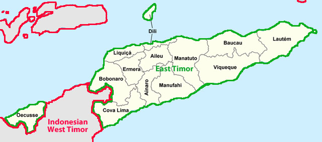
East Timor Districts

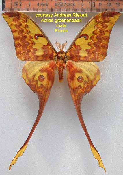
Actias groenendaeli male, Flores,
courtesy of Andreas Riekert, Germany

East Timor Districts

East Timor was colonized by Portugal in the 16th century, and was known as Portuguese Timor until Portugal's decolonization of the country. In late 1975, East Timor declared its independence, but later that year was invaded and occupied by Indonesia and was declared Indonesia's 27th province the following year. In 1999, following the United Nations-sponsored act of self-determination, Indonesia relinquished control of the territory and East Timor became the first new sovereign state of the 21st century on May 20, 2002.
Located in southeast Asia, the island of Timor is part of the Maritime Southeast Asia, and is the largest and easternmost of the Lesser Sunda Islands. To the north of the mountainous island are the Ombai Strait, Wetar Strait and the greater Banda Sea, to the south the Timor Sea separates the island from Australia, while to the west lies the Indonesian Province of East Nusa Tenggara. The highest mountain of East Timor is Tatamailau (also known as Mount Ramelau) at 2,963 meters (9,721 ft).
East Timor lies between latitudes 8° and 10°S, and longitudes 124° and 128°E.
The local climate is tropical and generally hot and humid, characterised by distinct rainy and dry seasons.
The easternmost area of Timor-Leste consists of the Paitchau Range and Iralalaro area. This area is the first conservation area in Timor-Leste, the Nino Konis Santana National Park. It contains the last remaining tropical dry forested area within the country. It hosts a number of unique plant and animal species and is sparsely populated.
Timur (northwest of the Northern Territory, Australia) seems to be the southern
limit of four species:
Actias groenendaeli, Roepke, 1954;
Antheraea (Antheraea) kelimutuensis, U. Paukstadt, L.H. Paukstadt & Suhardjono, 1997;
Antheraea lorosae
Cricula trifenestrata, (Helfer, 1837); and
and Samia yayukae, U. Paukstadt, Peigler & L.H. Paukstadt, 1993.
Cricula timorensis Naumann & D.A. Lane, 2010 is probably an endemic.
A single Attacus species is also reported from western Timur:
Attacus dohertyi, W. Rothschild, 1895 .
Cricula timorensis
Type locality for Cricula timorensis is East Timor, Bobanaro, 9º0'40"S, 125º21'49"E, 970 m.; Holotype: MNHU. male ?. 31.X.2002. leg. M.D. Lane.
I suspect there are additional species present.
Use your browser "Back" button to return to the previous page.
Ulrich Paukstadt: "Summary: This contribution on the wild silkmoths (Lepidoptera: Saturniidae) deals in general with the distribution of the genera and taxa of the Saturniidae in the Oriental Region and in particular with the taxa of Peninsular Malaysia. Thus far 25 taxa of the family Saturniidae were recorded for Peninsular Malaysia of which three species presently are considered being endemic to Peninsular Malaysia.
"Today the Malay Peninsula is well isolated from other fauna and flora regions by the Andaman Sea, the Strait of Malacca, the South China Sea, the Gulf of Thailand, and in its northern part by the Isthmus of Kra. Presently lowland taxa are unable to disperse due to the open seas which are surrounding the peninsula. Highland taxa are unable to disperse because there are no direct connections via higher mountain ranges between the Westmalaysian Highlands and either the Himalaya, the Barisan Range (Sumatera), the mountain ranges of Borneo or of Vietnam.
"During the glacials, Peninsula Malaysia was connected to the islands of Sumatera, Borneo, Jawa, and the Mekong Region via the exposed Sunda Shelf because the sea
level was about 180 m lower than the present sea level. Gene flow and dispersal of lowland taxa between regions which are islands or peninsulas today
(Westmalaysia, Sumatera, Jawa, Borneo, Mekong area) was possible via the exposed Sunda Shelf. Most likely even dispersal and gene flow of highland taxa
between the Malaysian Highlands and the Himalaya was temporary possible due to the cold climate, which caused that the altitudinal distributions of fauna
(and flora) was much lower than today.
"The botanists are using a divergent termination for their floral regions. For the Indonesian Archipelago the Dutch Colonists established the term East
Indies, and the term Sundaland was recently established by Nässig for the exposed lands on the Sunda Shelf in Southeast Asia."