Madagascar

Antherina suraka (female) courtesy of Leroy Simon.

Slightly less than twice the size of Arizona, Madagascar, the world's fourth largest island, is situated in the Indian Ocean, east of Mozambique, Africa.

The climate is tropical along the coast, temperate inland, and arid in the south with some desertification problems. The country has a narrow coastal plain, high plateau and mountains in the center with the highest point being Maromokotro, in the northeast, at 2,876 m.

Firewood is a primary source of fuel and there are potential problems with deforestation and soil erosion due to extensive cutting.

Hopefully these issues will be addressed before Madagascar loses some of its unique flora and fauna. I find the Antherina and Ceranchia genera to be especially beautiful.

Unfortunately the country is an illicit producer of cannabis (cultivated and wild varieties) used mostly for domestic consumption, and also a transshipment point for heroin. Any packages from Madagascar to the United States or Canada would likely be inspected by Customs, and it is, of course, illegal to import live animals without proper permits, likely not issued without inspected containment facilities.

There is considerable disagreement over Bouyer's reclassification of many moths from this country, particularly with the Maltagorea.

Most of these listings come from Rodolphe Rougerie (RR) with Bunaea alcinoe from Reinhart Roehrig (ReR) based on an entry, Josef Bijok 1955: Fliegende Kleiodien (=flying gems). It is suspected that B. alcinoe do not fly on Madagascar as the species does not appear in extensive collecting records. The sighting, with its accompanying valid image, is probably from an imported pupa for a collection or for food. Patrick Basquin, December 2014, indicates Bunaea alcinoe does not fly in Madagascar.

Since Madagascar is only slightly larger than France, it is hard to imagine that there could be so many different Maltagorea species present. I (Bill Oehlke) live in a hybrid zone (Maritime provinces (PEI), Canada) where I occasionally encounter natural hybrids of Hyalophora cecropia and Hyalophora columbia columbia. I know there are hybrid zones further west that involve blends between Hyalophora columbia columbia and Hyalophora columbia gloveri and yet further to the west between Hyalophora columbia gloveri and hyalophora euryalus.

Perhaps the topography of Madagascar helps to isolate and preserve the integrity of the different species.

In the east, a steep escarpment leads from the Central Highlands down into a ribbon of rain forest with a narrow coast. This escarpment may separate some eastern and western species.

In the west there is a much more gradual descent from the central highlands toward the coast, with remnants of deciduous forest and savanna-like plains (which in the south and southwest, are quite dry and host spiny desert and baobabs). Hence there may be west coast species and southern species and central highland (747-1341m) species.

The central highlands are characterised by valleys, lying between barren hills. It is possible that the barren hills form a natural barrier between different species populations in the valleys, or vice-versa.

The island's highest peak, Maromokotro, at 2,876 metres (9,436 ft), is found in the Tsaratanana Massif, located in the far north of the country. The Ankaratra Massif is in the central area south of the capital Antananarivo and hosts the third highest mountain on the island, Tsiafajavona, with an altitude of 2,642 metres (8,668 ft). Further south is the Andringitra massif which has several peaks over 2,400 metres (7,900 ft) including the second and fourth highest peaks, Pic Imarivolanitra, more widely known as Pic Boby (2,658 metres / 8,720 feet), and Pic Bory (2,630 metres / 8,630 feet). Other peaks in the massif include Pic Soaindra (2,620 metres / 8,600 feet) and Pic Ivangomena (2,556 metres / 8,386 feet). This massif also contains the Andringitra Reserve. On very rare occasions, this region experiences snow in winter due to its high altitude. The northern part of Madagascar may only host montane Maltagorea species.

If the geographic features mentioned above do have an influence on isolating populations, then specific locations might help to identify different species. Any information that you might have would be appreciated.

There are two seasons: a hot, rainy season from November to April, and a cooler, dry season from May to October.

Patrick Basquin has looked at this list in December 2014 and adds the following:

"First Bunaea alcinoe is not in Madagascar, he is replaced by Bunaea aslauga Kirby, 1877. Maltagorea cincta = Maltagorea griveaudi ?", indicating cincta is a synonym of M. griveaudi, is questionable. Patrick recognizes griveaudi as a separate and distinct species.

Patrick also questions Ceranchia reticolens which is quite likely a synonym of Cerancha apollina, and he has described six new Maltagorea species/subspecies, described in 2013, which I have added to the list: Maltagorea altivola; Maltagorea ambahona; Maltagorea mariae; Maltagorea pseudomariae; Maltagorea vulpina tapiae; Maltagorea vulpina viettei.
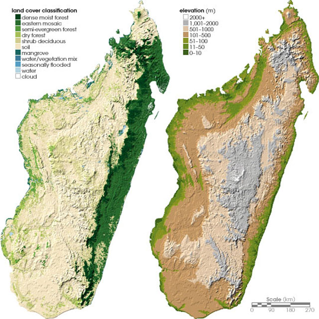
http://www.mapsorama.com/land-cover-and-topographical-map-of-madagascar/

Maltagorea species, possibly vulpina, Ambohitantely, (NW of Antananarivo) Madagascar,
courtesy of David Lees, very tentative id put forward by Rodolphe Rougerie.

David Lees, Scientific Associate, Department of Entomology, Natural History Museum, and Researcher, Centre de Recherche d'Orléans, INRA, indicates the hostplant is likely an Uapaca species, probably bojeri, with common name of Tapia tree.

The tapia tree grows on the western highlands.

Bunaeini:
Bunaea aslauga RR


Saturniini:
Antherina suraka RR
A. suraka australis PB
Argema mittrei RR
Ceranchia apollina RR


Urotini:
M. altivola Ambatofitorahana
M. ambahona Ankaratra
M. andriai RR (southern)
M. ankaratra RR (central)
M. auricolor RR (ne)
M. a. variabile RR (central)
M. basquini RR (northeast)
M. cincta RR (rare) ???
M. dentata RR (eastcentral)
M. dubiefi TB (eastcentral)
M. dura RR (north)
M.fusicolor (southern)
M. griveaudi RR (eastcent.)
M. madagascariensis RR (central)
M. mariae (eastcentral)
M. monsarrati RR (central)
M. ornata RR (widespread)
M. pseudomariae (eastcentral)
M. pseudovulpina
M. rostaingi RR
M. rubriflava RR (cen+nor)
M. sogai RR (northern)
M. vulpina RR (southern half)
M. vulpina tapiae
M. vulpina viettei


Of the Saturniinae subfamily, the Saturniini spin cocoons, while the Urotini and Bunaeini pupate underground.

Use your browser "Back" button to return to the previous page.

Some additional information regarding ecosystems on Madagascar:

TROPICAL MOIST FORESTS

Coastal rainforest
Elevation: sea level
These forests are some of the rarest in Madagascar. The Bradt guide describes these forests as follows: "Rooted in sand, washed with salty air, battered by cyclones and bordering lagoons and marshes the coastal forest harbors a very unusual community. The architecture of the forest is similar to the more widespread lowland forest, but the plants here are different: they are salt-tolerant and highly efficient at extracting water and nutrients from, the shallow porous sand beneath them." These forests are comparable in structure to the white sands or blackwater forests of the Amazon basin or the heath forests of southeast Asia.
Examples: forests north of Fort Dauphin and around Antalaha/Sambava

Lowland rainforest
Elevation: 0-800 m
Lowland rainforests are the most biologically rich ecosystems in Madagascar. These forests are characterized by warm temperatures, humidity that hovers around 100% year round, more than 200 cm (80 inches) of rain annually, and a well developed canopy.
Examples: Masoala (including Nosy Mangabe), Makira, Mananara-Nord

Montane rainforest
Elevation: 800-1300 m
Montane rainforest is cooler than lowland rainforest with a lower canopy (18-25 m) and abundant epiphyte growth (especially ferms and orchids), mosses and lichens.
Examples: Ranomafana, Andasibe-Mantadia , Montagne d' Ambre, Marojejy

Cloud forest / High mountain sclerophyllous forest / High altitude montane forest
Elevation: above 1300 m
These forests are cool and often enveloped in mist. Trees are typically shorter than those of lowland forest resulting in a less developed canopy at a height of 10 meters or less. The ground may be covered with a thick layer of mosses and lichens and epiphytes like orchids and ferns thrive with the abundance of moisture from the passing fog. Characterized by rapid changes in temperature and humidity.
Examples: Marojejy, Andringitra

High elevation scrub
Elevation: above 1300 m
At the high elevations of Madagascar's tallest peaks, forests yield to a mosaic of stunted montane vegetation, lichens, peat bogs, and grasses, and rock exposures. In this zone you can may find orchids and minature palm trees.
Examples: Marojejy, Andringitra

Sambirano forest
Elevation: 0-1000 m
Sambirano forest is found in the northwestern part of the island and serves as transition between the eastern moist forests and the western dry forests. These forests, especially at low elevations, are highly threatened.
Examples: Lokobe, parts of the Tsarantanana Massif, region around Manangorivo

SOUTHERN AND WESTERN DRY FORESTS

Dry deciduous forest
Elevation: 0-800 m
These seasonal forests are found from northwestern Madagascar south to near Fort Dauphin. While less diverse than their eastern counterparts, the island's dry deciduous forests have high levels of endemicism and many species of lemurs. Deciduous trees lose their leaves during the 6-8 month dry season. When rains return these forests erupt in a sea of bright green leaves.
Examples: Kirindy, Zombitse-Vohibasia, Berenty, Bemaraha

Limestone tsingy formations
Within the dry deciduous forests of Madagascar you can find the island's limestone pinnacle formations known locally as "tsingy." Because limestone is highly porous, these regions often wave well-developed caves and underground rivers.
Examples: Ankarana, Bemaraha, Namoroka

Tapia woodlands
Visitors to Isalo will see groves of Tapia trees (Uapaca bojeri). These trees, resistant to the frequent grass fires of the Hauts Plateaux are known locally for their edible fruit and as habitat for a wild silkworm.
Examples: Isalo

Spiny forest
Madagascar's most unique forests are also some of its most endangered. Madagascar's so-called spiny forests (or "spiny desert") are endemic to the arid southern tip of the island. Spiny forests are dominated by plants of the Didiereaceae family, which is unique to Madagascar as are 95% of the species found in this ecosystem. Didiereaceae closely resemble some forms of cacti but are not related. Unlike catci, Didiereaceae species produce small deciduous leaves which are protected by menacing thorns and spines that grow directly out of the plant's many branches. Madagascar's spiny forests are being rapidly destroyed for use as charcoal and building material.
Examples: Berenty, Bezaha Mahafaly, Ifaty, Cap Sainte Marie

SECONDARY (MAN-MADE) COMMUNITIES

Grasslands of the Hauts Plateaux ("bosaka")
The central of highlands of Madagascar once had significant forest cover but generations of clearing for Zebu cattle and agriculture have left most of the countryside a sea of grass. Lacking roots to anchor the soil, hillsides slide away (locally known as "lavaka") leaving deep red scars across the landscape and eroding massive amounts of topsoil into rivers and streams. In some areas the French planted Eucalyptus and pine plantations to help stem erosion and provide wood for timber.
Examples: Central plateau outside Antananarivo

Palm savanna
In western Madagascar slash-and-burn clearing has left a landscape of grasses and scattered palm trees.
Examples: Region around Isalo

Secondary forest ("Savoka")
Savoka is the local name for the secondary vegetation that grows back after rainforest is cleared and burned. Generally vegetation consists of a limited number of weedy species some of which are exotic. Many plants and animals typically found in primary forests cannot survive in fragmented and disturbed ecosystems.
Examples: Much of the eastern rainforest has been replaced with secondary forest. You will find savoka around most national parks having moist forest. Western scrublands Dry deciduous forests in western Madagascar have been burned and replaced with scrub vegetation that is neither attractive nor supports much animal life. In the region between Bemaraha and Morondava, dry scrublands may have scattered surviving baobab trees.

Cactus scrub
In southern Madagascar cleared spiny forest gives way to introduced cacti. In the area around Berenty cactus is some abundant is some areas you would like it a local species.

WETLANDS

Lakes, marshes, swamps
Madagascar has many wetland ecosystems including lakes, marshes, swamps and lagoons. Typically found in coastal regions, these habitats support a disproportionate amount of Madagascar's birdlife.
Examples: Lake Alaotra, Bay de baly, Tsimanampetsotsa

Mangrove forests
According to the Bradt guide, Madagascar has the largest expanse of mangrove forests in the western Indian Ocean -- more than 300,000 ha. Mangrove forest is found in silt-rich, saline (brackish water) habitats worldwide, generally along large river deltas, estuaries, and coastal areas. It is characterized by low tree diversity, almost exclusively mangroves, with a low broken canopy. Mangroves are evergreen trees and shrubs that are well adapted to their salty and swampy habitat by having breathing roots (pneumatophores) that emerge from the oxygen-deficient mud to absorb oxygen.
Examples: Mahajanga, Marovoay.

Ranomafana National Park is said to have populations of fusicolor and auricolor, and aslauga, mittrei, suraka.

auricolor is possibly a montane species
dura Tsarabaria northeast coast, 39m
vulpina is known from massif l'Ankarana; Ranomena 125m, Anjozorobe 1253m,
Ambohiborona 1680m
monsarrati is known from Ambatofinandrahana and west of Imito
andriai in southern tip from nw of Jafaro and east south of Behisatra
ankarata due west of Antananarvo and east of Miandraviro or Miandranvo, Ambohiborona 1680m
basquini extreme northeast Amboditsoba 10m
dentata east near Lakato 672m
madagascariensis Manjakavaradrano, slightly northwest of north central Ambohiborona 1680m,
sogai northern: near Tsaratanana Nature Reserve